Journal of Zhejiang Agricultural Sciences ›› 2026, Vol. 67 ›› Issue (4): 1024-1034.DOI: 10.16178/j.issn.0528-9017.20250645
Previous Articles Next Articles
LI Hongrong1( ), LI Jiao1, SHAO Jing'an1,2()
Received:2025-09-07
Online:2026-04-11
Published:2026-04-17
Contact:
SHAO Jing'an
CLC Number:
LI Hongrong, LI Jiao, SHAO Jing'an. Topographic gradient differentiation and spatio⁃temporal evolution of ecological sensitivity in the Chongqing section of the Three Gorges Reservoir Area[J]. Journal of Zhejiang Agricultural Sciences, 2026, 67(4): 1024-1034.
Add to citation manager EndNote|Ris|BibTeX
URL: http://www.zjnykx.cn/EN/10.16178/j.issn.0528-9017.20250645
| 准则层 | 标准层 | 生态敏感性等级 | 权重/% | 参考文献 | ||||
|---|---|---|---|---|---|---|---|---|
| 不敏感 | 轻度敏感 | 中度敏感 | 重度敏感 | 极度敏感 | ||||
| 土壤侵蚀 | 土壤侵蚀模量/(t?km-2) | 0~0.25 | >0.25~0.50 | >0.50~0.80 | >0.80~1.50 | >1.50 | 27.25 | [ |
| 石漠化 | 植被覆盖度/% | >80 | >60~80 | >40~60 | >15~40 | ≤15 | 6.36 | [ |
| 坡度/(°) | ≤8 | >8~15 | >15~25 | >25~45 | >45 | 10.11 | [ | |
| 土壤类型 | 水稻土、黑钙土 | 褐土、寒钙土、冷棕钙土、灰钙土、暗钙土 | 棕壤土、黄棕壤土、黄褐土、红壤、中性紫色土、赤红壤 | 黄壤土、酸性紫色土、黄棕壤土、粗骨土 | 石灰(岩)土、石灰性紫色土 | 12.26 | [ | |
| 人类活动 | 土地利用 | 有林地、高覆盖度草地、未利用地 | 水田、灌木林、中覆盖度草地、农村居民点 | 其他林地和水域 | 旱地、疏林地、低覆盖度草地、其他建设用地 | 城镇用地 | 23.49 | [ |
| 自然灾害 | 地质灾害点距离/km | >1.2 | >0.8~1.2 | >0.5~0.8 | >0.2~0.5 | ≤0.2 | 7.92 | [ |
| 水系距离/km | >1.00 | >0.50~1.00 | >0.20~0.50 | >0.05~0.20 | ≤0.05 | 4.88 | [ | |
| 高程/km | ≤0.5 | >0.5~1.0 | >1.0~1.5 | >1.5~2.0 | >2.0 | 4.37 | [ | |
| 坡度/(°) | ≤8 | >8~15 | >15~25 | >25~45 | >45 | 3.36 | [ | |
Table 1 The indicator system and classification criteria for ecological sensitivity evaluation
| 准则层 | 标准层 | 生态敏感性等级 | 权重/% | 参考文献 | ||||
|---|---|---|---|---|---|---|---|---|
| 不敏感 | 轻度敏感 | 中度敏感 | 重度敏感 | 极度敏感 | ||||
| 土壤侵蚀 | 土壤侵蚀模量/(t?km-2) | 0~0.25 | >0.25~0.50 | >0.50~0.80 | >0.80~1.50 | >1.50 | 27.25 | [ |
| 石漠化 | 植被覆盖度/% | >80 | >60~80 | >40~60 | >15~40 | ≤15 | 6.36 | [ |
| 坡度/(°) | ≤8 | >8~15 | >15~25 | >25~45 | >45 | 10.11 | [ | |
| 土壤类型 | 水稻土、黑钙土 | 褐土、寒钙土、冷棕钙土、灰钙土、暗钙土 | 棕壤土、黄棕壤土、黄褐土、红壤、中性紫色土、赤红壤 | 黄壤土、酸性紫色土、黄棕壤土、粗骨土 | 石灰(岩)土、石灰性紫色土 | 12.26 | [ | |
| 人类活动 | 土地利用 | 有林地、高覆盖度草地、未利用地 | 水田、灌木林、中覆盖度草地、农村居民点 | 其他林地和水域 | 旱地、疏林地、低覆盖度草地、其他建设用地 | 城镇用地 | 23.49 | [ |
| 自然灾害 | 地质灾害点距离/km | >1.2 | >0.8~1.2 | >0.5~0.8 | >0.2~0.5 | ≤0.2 | 7.92 | [ |
| 水系距离/km | >1.00 | >0.50~1.00 | >0.20~0.50 | >0.05~0.20 | ≤0.05 | 4.88 | [ | |
| 高程/km | ≤0.5 | >0.5~1.0 | >1.0~1.5 | >1.5~2.0 | >2.0 | 4.37 | [ | |
| 坡度/(°) | ≤8 | >8~15 | >15~25 | >25~45 | >45 | 3.36 | [ | |
| 区域 | 生态敏感性指数 | 敏感性等级 | 面积占比/% | 2000—2020年面积占比变幅/百分点 | ||||
|---|---|---|---|---|---|---|---|---|
| 2020年 | 2010年 | 2020年 | 2020年 | 2010年 | 2020年 | |||
| 库腹东部 | 3.14 | 3.06 | 2.88 | 不敏感 | 3.40 | 4.04 | 7.20 | 3.80 |
| 轻度敏感 | 9.64 | 11.86 | 16.76 | 7.12 | ||||
| 中度敏感 | 10.61 | 11.50 | 11.79 | 1.18 | ||||
| 重度敏感 | 17.45 | 15.53 | 8.18 | -9.27 | ||||
| 极度敏感 | 7.01 | 5.17 | 4.18 | -2.83 | ||||
| 库腹西部 | 2.88 | 2.75 | 2.71 | 不敏感 | 5.01 | 6.67 | 7.55 | 2.54 |
| 轻度敏感 | 9.51 | 11.49 | 10.47 | 0.96 | ||||
| 中度敏感 | 6.41 | 6.03 | 6.96 | 0.55 | ||||
| 重度敏感 | 7.19 | 4.89 | 3.80 | -3.39 | ||||
| 极度敏感 | 2.02 | 1.05 | 1.36 | -0.66 | ||||
| 库尾部 | 2.57 | 2.48 | 2.56 | 不敏感 | 8.27 | 9.42 | 8.27 | 0 |
| 轻度敏感 | 6.68 | 6.86 | 6.18 | -0.50 | ||||
| 中度敏感 | 3.42 | 3.03 | 4.36 | 0.94 | ||||
| 重度敏感 | 2.53 | 1.95 | 2.26 | -0.27 | ||||
| 极度敏感 | 0.84 | 0.49 | 0.69 | -0.15 | ||||
| 全库区 | 2.94 | 2.84 | 2.76 | 不敏感 | 16.67 | 20.13 | 23.01 | 6.34 |
| 轻度敏感 | 25.84 | 30.21 | 33.40 | 7.56 | ||||
| 中度敏感 | 20.43 | 20.56 | 23.11 | 2.68 | ||||
| 重度敏感 | 27.18 | 22.37 | 14.24 | -12.94 | ||||
| 极度敏感 | 9.87 | 6.72 | 6.23 | -3.64 | ||||
Table 2 Areal proportions of each sensitivity level in the Chongqing section of the Three Gorges Reservoir Area,2000-2020
| 区域 | 生态敏感性指数 | 敏感性等级 | 面积占比/% | 2000—2020年面积占比变幅/百分点 | ||||
|---|---|---|---|---|---|---|---|---|
| 2020年 | 2010年 | 2020年 | 2020年 | 2010年 | 2020年 | |||
| 库腹东部 | 3.14 | 3.06 | 2.88 | 不敏感 | 3.40 | 4.04 | 7.20 | 3.80 |
| 轻度敏感 | 9.64 | 11.86 | 16.76 | 7.12 | ||||
| 中度敏感 | 10.61 | 11.50 | 11.79 | 1.18 | ||||
| 重度敏感 | 17.45 | 15.53 | 8.18 | -9.27 | ||||
| 极度敏感 | 7.01 | 5.17 | 4.18 | -2.83 | ||||
| 库腹西部 | 2.88 | 2.75 | 2.71 | 不敏感 | 5.01 | 6.67 | 7.55 | 2.54 |
| 轻度敏感 | 9.51 | 11.49 | 10.47 | 0.96 | ||||
| 中度敏感 | 6.41 | 6.03 | 6.96 | 0.55 | ||||
| 重度敏感 | 7.19 | 4.89 | 3.80 | -3.39 | ||||
| 极度敏感 | 2.02 | 1.05 | 1.36 | -0.66 | ||||
| 库尾部 | 2.57 | 2.48 | 2.56 | 不敏感 | 8.27 | 9.42 | 8.27 | 0 |
| 轻度敏感 | 6.68 | 6.86 | 6.18 | -0.50 | ||||
| 中度敏感 | 3.42 | 3.03 | 4.36 | 0.94 | ||||
| 重度敏感 | 2.53 | 1.95 | 2.26 | -0.27 | ||||
| 极度敏感 | 0.84 | 0.49 | 0.69 | -0.15 | ||||
| 全库区 | 2.94 | 2.84 | 2.76 | 不敏感 | 16.67 | 20.13 | 23.01 | 6.34 |
| 轻度敏感 | 25.84 | 30.21 | 33.40 | 7.56 | ||||
| 中度敏感 | 20.43 | 20.56 | 23.11 | 2.68 | ||||
| 重度敏感 | 27.18 | 22.37 | 14.24 | -12.94 | ||||
| 极度敏感 | 9.87 | 6.72 | 6.23 | -3.64 | ||||
Fig.1 Areal proportions of ecological zone types by stratum in the Chongqing section of the Three Gorges Reservoir Area
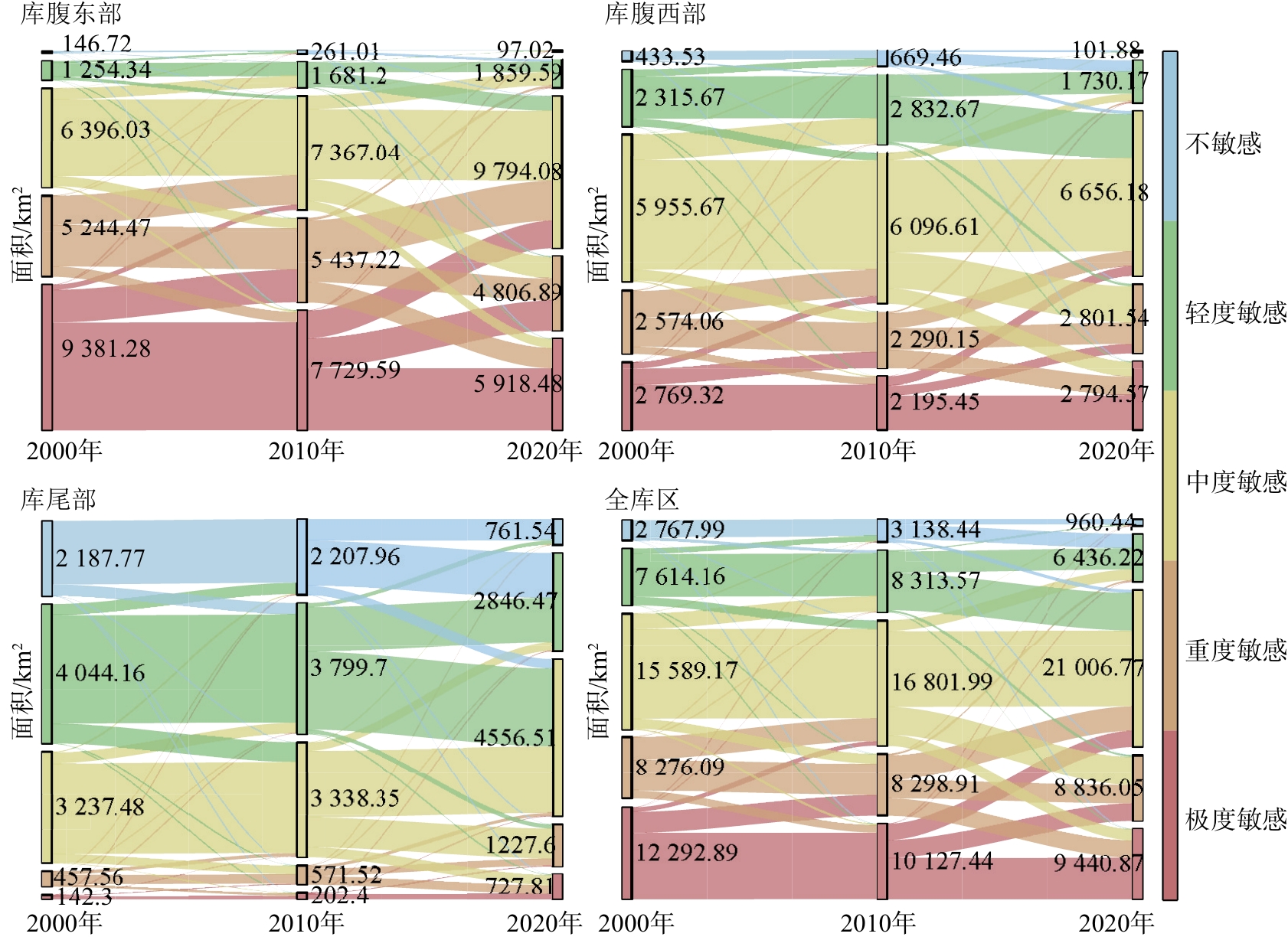
Fig.2 Dynamics of ecological sensitive zones,2000-2020
| 敏感分区 | 单一动态度 | ||
|---|---|---|---|
| 2000—2010年 | 2010—2020年 | 2000—2020年 | |
| 不敏感区 | 2.07 | 1.43 | 3.80 |
| 轻度敏感区 | 1.69 | 1.06 | 2.93 |
| 中度敏感区 | 0.06 | 1.24 | 1.31 |
| 重度敏感区 | -1.77 | -3.63 | -4.76 |
| 极度敏感区 | -3.19 | -0.73 | -3.69 |
| 综合动态度 | 1.56 | 1.72 | 1.66 |
Table 3 Dynamic degree of change for each ecologically sensitive area,2000-2020
| 敏感分区 | 单一动态度 | ||
|---|---|---|---|
| 2000—2010年 | 2010—2020年 | 2000—2020年 | |
| 不敏感区 | 2.07 | 1.43 | 3.80 |
| 轻度敏感区 | 1.69 | 1.06 | 2.93 |
| 中度敏感区 | 0.06 | 1.24 | 1.31 |
| 重度敏感区 | -1.77 | -3.63 | -4.76 |
| 极度敏感区 | -3.19 | -0.73 | -3.69 |
| 综合动态度 | 1.56 | 1.72 | 1.66 |
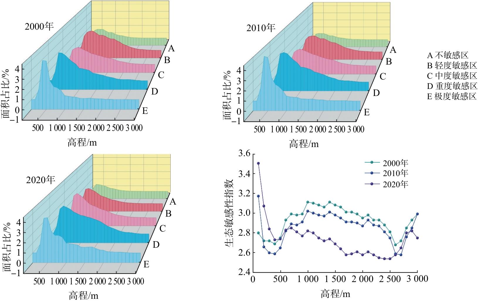
Fig.3 Areal proportion and sensitivity index of each sensitive zone across elevation belts,2000-2020
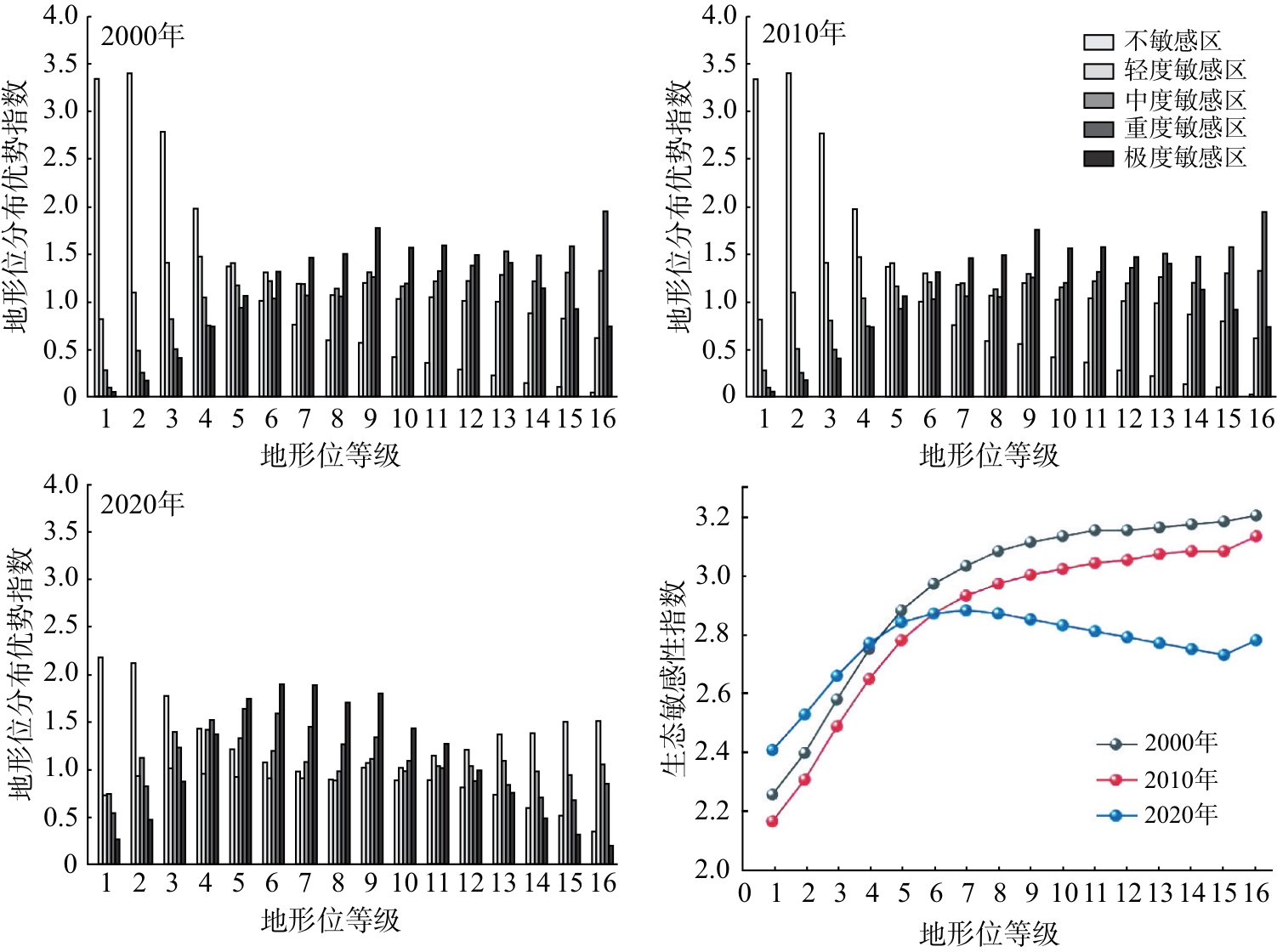
Fig.4 Distribution advantage index and sensitivity index across terrain niches
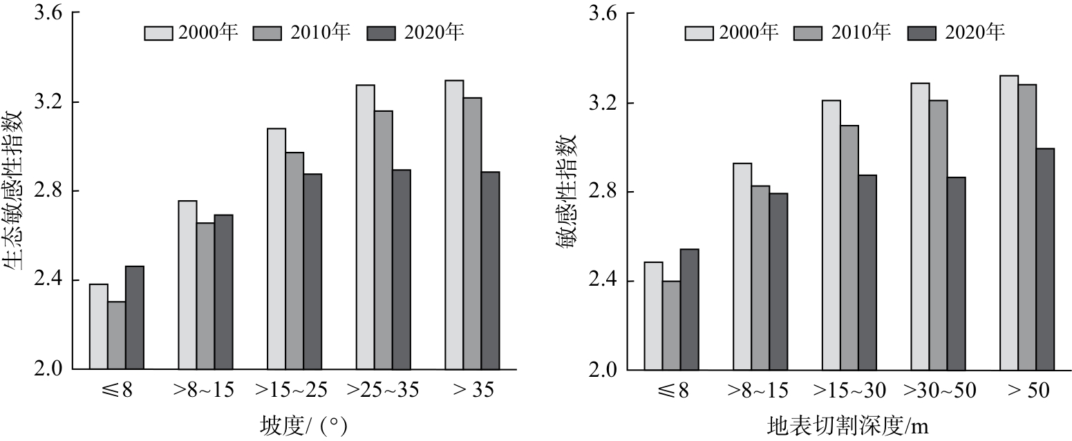
Fig.5 Ecological sensitivity across gradients of slope and surface cutting depth,2000-2020
| 分区 | 年份 | 不同坡度(°)下各敏感区面积占比 | 不同地表切割深度(m)下各敏感区面积占比 | ||||||||
|---|---|---|---|---|---|---|---|---|---|---|---|
| ≤8 | >8~15 | >15~25 | >25~35 | >35 | ≤8 | >8~15 | >15~30 | >30~50 | >50 | ||
| 不敏感 | 2000 | 9.00 | 5.46 | 1.87 | 0.28 | 0.06 | 11.13 | 4.45 | 1.04 | 0.05 | 0.00 |
| 2010 | 10.17 | 6.77 | 2.65 | 0.45 | 0.09 | 12.75 | 5.76 | 1.54 | 0.09 | 0.00 | |
| 2020 | 8.04 | 7.28 | 4.92 | 1.92 | 0.85 | 10.28 | 7.54 | 4.42 | 0.73 | 0.05 | |
| 轻度敏感 | 2000 | 5.80 | 8.61 | 7.68 | 2.70 | 1.06 | 8.61 | 9.98 | 6.29 | 0.89 | 0.07 |
| 2010 | 5.45 | 9.34 | 9.70 | 4.03 | 1.68 | 8.43 | 11.60 | 8.68 | 1.39 | 0.11 | |
| 2020 | 4.67 | 6.73 | 10.11 | 7.40 | 4.50 | 6.76 | 9.69 | 12.95 | 3.63 | 0.37 | |
| 中度敏感 | 2000 | 1.86 | 4.98 | 7.19 | 4.05 | 2.36 | 3.36 | 7.28 | 7.68 | 1.88 | 0.23 |
| 2010 | 1.44 | 4.44 | 7.42 | 4.58 | 2.68 | 2.76 | 7.01 | 8.41 | 2.12 | 0.26 | |
| 2020 | 3.51 | 5.50 | 6.64 | 4.49 | 2.97 | 5.49 | 7.14 | 7.83 | 2.27 | 0.37 | |
| 重度敏感 | 2000 | 0.95 | 4.11 | 9.27 | 7.53 | 5.32 | 2.12 | 7.73 | 12.59 | 4.07 | 0.67 |
| 2010 | 0.61 | 2.99 | 7.42 | 6.59 | 4.76 | 1.46 | 5.97 | 10.71 | 3.63 | 0.61 | |
| 2020 | 1.32 | 3.51 | 5.04 | 2.63 | 1.74 | 2.54 | 5.24 | 4.91 | 1.25 | 0.31 | |
| 极度敏感 | 2000 | 0.16 | 0.99 | 3.44 | 3.48 | 1.80 | 0.43 | 2.49 | 5.40 | 1.38 | 0.17 |
| 2010 | 0.09 | 0.60 | 2.26 | 2.38 | 1.39 | 0.25 | 1.60 | 3.66 | 1.05 | 0.15 | |
| 2020 | 0.23 | 1.12 | 2.74 | 1.61 | 0.54 | 0.58 | 2.32 | 2.88 | 0.40 | 0.05 | |
Table 4 Areal distribution of each sensitive zone across slope and surface cutting depth gradients,2000-2020
| 分区 | 年份 | 不同坡度(°)下各敏感区面积占比 | 不同地表切割深度(m)下各敏感区面积占比 | ||||||||
|---|---|---|---|---|---|---|---|---|---|---|---|
| ≤8 | >8~15 | >15~25 | >25~35 | >35 | ≤8 | >8~15 | >15~30 | >30~50 | >50 | ||
| 不敏感 | 2000 | 9.00 | 5.46 | 1.87 | 0.28 | 0.06 | 11.13 | 4.45 | 1.04 | 0.05 | 0.00 |
| 2010 | 10.17 | 6.77 | 2.65 | 0.45 | 0.09 | 12.75 | 5.76 | 1.54 | 0.09 | 0.00 | |
| 2020 | 8.04 | 7.28 | 4.92 | 1.92 | 0.85 | 10.28 | 7.54 | 4.42 | 0.73 | 0.05 | |
| 轻度敏感 | 2000 | 5.80 | 8.61 | 7.68 | 2.70 | 1.06 | 8.61 | 9.98 | 6.29 | 0.89 | 0.07 |
| 2010 | 5.45 | 9.34 | 9.70 | 4.03 | 1.68 | 8.43 | 11.60 | 8.68 | 1.39 | 0.11 | |
| 2020 | 4.67 | 6.73 | 10.11 | 7.40 | 4.50 | 6.76 | 9.69 | 12.95 | 3.63 | 0.37 | |
| 中度敏感 | 2000 | 1.86 | 4.98 | 7.19 | 4.05 | 2.36 | 3.36 | 7.28 | 7.68 | 1.88 | 0.23 |
| 2010 | 1.44 | 4.44 | 7.42 | 4.58 | 2.68 | 2.76 | 7.01 | 8.41 | 2.12 | 0.26 | |
| 2020 | 3.51 | 5.50 | 6.64 | 4.49 | 2.97 | 5.49 | 7.14 | 7.83 | 2.27 | 0.37 | |
| 重度敏感 | 2000 | 0.95 | 4.11 | 9.27 | 7.53 | 5.32 | 2.12 | 7.73 | 12.59 | 4.07 | 0.67 |
| 2010 | 0.61 | 2.99 | 7.42 | 6.59 | 4.76 | 1.46 | 5.97 | 10.71 | 3.63 | 0.61 | |
| 2020 | 1.32 | 3.51 | 5.04 | 2.63 | 1.74 | 2.54 | 5.24 | 4.91 | 1.25 | 0.31 | |
| 极度敏感 | 2000 | 0.16 | 0.99 | 3.44 | 3.48 | 1.80 | 0.43 | 2.49 | 5.40 | 1.38 | 0.17 |
| 2010 | 0.09 | 0.60 | 2.26 | 2.38 | 1.39 | 0.25 | 1.60 | 3.66 | 1.05 | 0.15 | |
| 2020 | 0.23 | 1.12 | 2.74 | 1.61 | 0.54 | 0.58 | 2.32 | 2.88 | 0.40 | 0.05 | |
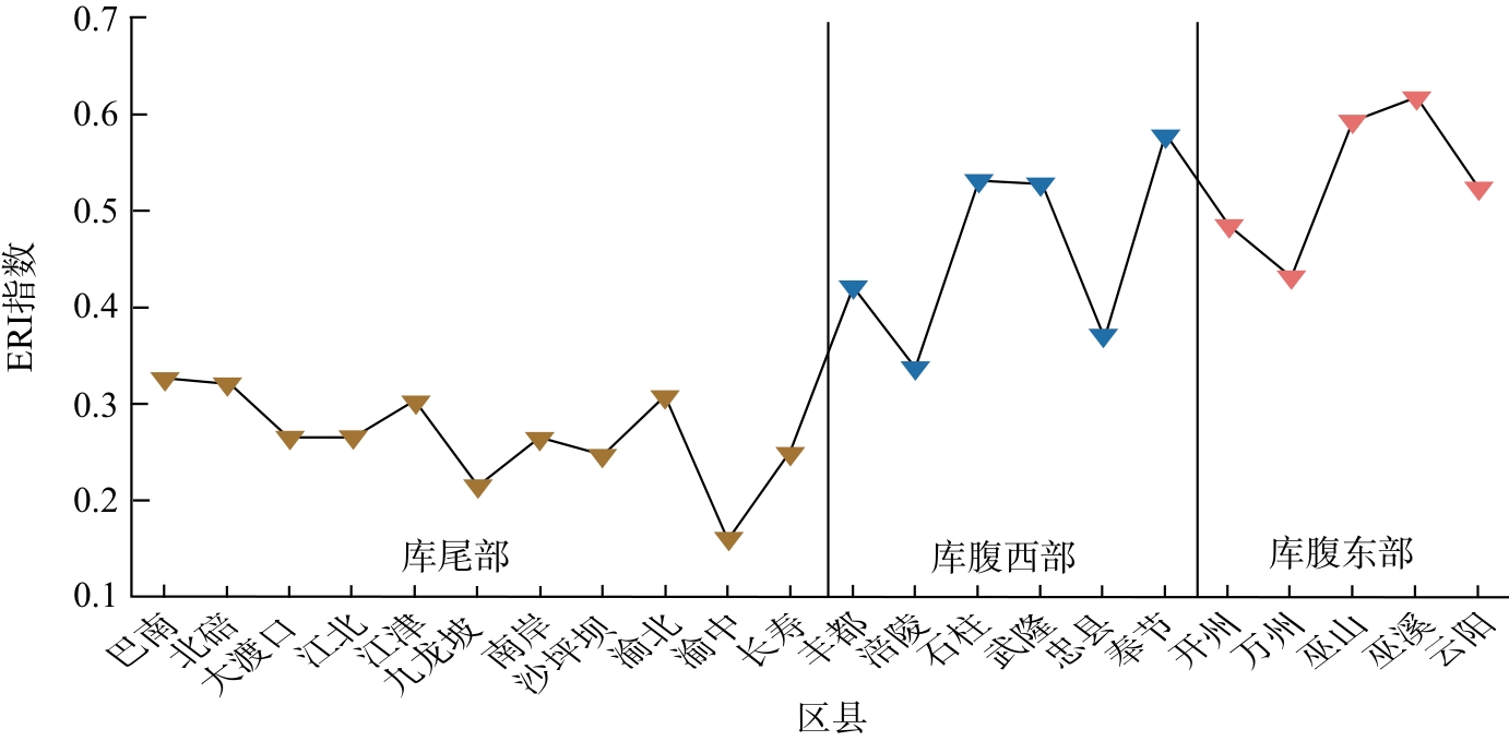
Fig.6 Ecological risk index(ERI)for each district and county in the Chongqing section of the Three Gorges Reservoir Area
| [1] | 欧阳志云,王效科,苗鸿. 中国生态环境敏感性及其区域差异规律研究[J]. 生态学报,2000,20(1):9-12. |
| OUYANG Z Y, WANG X K, MIAO H. China's eco-environmental sensitivity and its spatial heterogeneity[J]. Acta Ecologica Sinica,2000,20(1):9-12. | |
| [2] | 刘军会,高吉喜,马苏,等. 中国生态环境敏感区评价[J]. 自然资源学报,2015,30(10):1607-1616. |
| LIU J H, GAO J X, MA S,et al. Evaluation of ecological sensitivity in China[J]. Journal of Natural Resources,2015,30(10):1607-1616. | |
| [3] | 石旭霞. 中国典型森林总初级生产力温度敏感性的影响因子研究[D]. 北京:北京林业大学,2019. |
| SHI X X. Factors affecting the temperature sensitivity of gross primary productivity in typical forests of China[D]. Beijing:Beijing Forestry University,2019. | |
| [4] | 倪宁淇,谢佳鑫,刘小莽,等. 基于径流对气候变化敏感性指标的多源数据质量评估[J]. 地理学报,2022,77(9):2280-2291. |
| NI N Q, XIE J X, LIU X M,et al. Multi-source data quality assessment based on the index of runoff sensitivity to climate change[J]. Acta Geographica Sinica,2022,77(9):2280-2291. | |
| [5] | 董李勤,章光新. 全球气候变化对湿地生态水文的影响研究综述[J]. 水科学进展,2011,22(3):429-436. |
| DONG L Q, ZHANG G X. Review of the impacts of climate change on wetland ecohydrology[J]. Advances in Water Science,2011,22(3):429-436. | |
| [6] | 连虎刚,刘春芳,倪博文,等. 西北干旱区自然保护地体系生态网络构建及优化:以河西走廊为例[J]. 应用生态学报,2025,36(1):259-270. |
| LIAN H G, LIU C F, NI B W,et al. Construction and optimization of ecological network of natural protected areas in the northwestern arid region:a case study of Hexi Corridor[J]. Chinese Journal of Applied Ecology,2025,36(1):259-270. | |
| [7] | MA J G, SCOTT N R, DEGLORIA S D,et al. Siting analysis of farm-based centralized anaerobic digester systems for distributed generation using GIS[J]. Biomass and Bioenergy,2005,28(6):591-600. |
| [8] | 周超凡,王毅勇. 基于DPSR模型的宝鸡市生态环境安全评价及其障碍因子研究[J]. 环境科学与管理,2023,48(6):167-172. |
| ZHOU C F, WANG Y Y. Evaluation of ecological security environment in Baoji based on DPSR model and its influencing factors[J]. Environmental Science and Management,2023,48(6):167-172. | |
| [9] | 林海明,杜子芳. 主成分分析综合评价应该注意的问题[J]. 统计研究,2013,30(8):25-31. |
| LIN H M, DU Z F. Some problems in comprehensive evaluation in the principal component analysis[J]. Statistical Research,2013,30(8):25-31. | |
| [10] | 杨李玲,和阳一丹,唐红,等. 云南红河流域土地利用变化的地形梯度效应及其功能分区[J]. 云南大学学报(自然科学版),2024,46(2):276-287. |
| YANG L L, HE Y Y D, TANG H,et al. Terrain gradient effect and functional zoning of land use change in the Red River Basin of Yunnan Province[J]. Journal of Yunnan University(Natural Sciences Edition),2024,46(2):276-287. | |
| [11] | 刘晓娜,刘春兰,张丛林,等. 青藏高原国家公园群生态系统完整性与原真性评估框架[J]. 生态学报,2021,41(3):833-846. |
| LIU X N, LIU C L, ZHANG C L,et al. Ecosystem integrity and authenticity assessment framework in the Qinghai-Tibet Plateau National Park Cluster[J]. Acta Ecologica Sinica,2021,41(3):833-846. | |
| [12] | 王世杰,李阳兵,李瑞玲. 喀斯特石漠化的形成背景、演化与治理[J]. 第四纪研究,2003,23(6):657-666. |
| WANG S J, LI Y B, LI R L. Karst rocky desertification:formation background,evolution and comprehensive taming[J]. Quaternary Sciences,2003,23(6):657-666. | |
| [13] | YATES A G, BRUA R B, CULP J M,et al. Sensitivity of structural and functional indicators depends on type and resolution of anthropogenic activities[J]. Ecological Indicators,2014,45:274-284. |
| [14] | 中华人民共和国水利部. 土壤侵蚀分类分级标准: [S]. 北京:中国水利水电出版社,2008:1-26. |
| [15] | 高敏,刘学录,郁文婷,等. 庄浪河流域生态保护重要性评价[J]. 甘肃农业大学学报,2024,59(3):263-272. |
| GAO M, LIU X L, YU W T,et al. Evaluation of the importance of ecological protection in the Zhuanglang River Basin[J]. Journal of Gansu Agricultural University,2024,59(3):263-272. | |
| [16] | 张静,秦公伟,苏雪萌,等. 秦巴山片区生态敏感性评价及地形梯度特征[J]. 水土保持学报,2024,38(5):332-342. |
| ZHANG J, QIN G W, SU X M,et al. Evaluation of ecological sensitivity and its topographic gradient characteristics in Qinling-Bashan Mountains[J]. Journal of Soil and Water Conservation,2024,38(5):332-342. | |
| [17] | 闫天亮,王承武,陈梦茜,等. 基于土地生态敏感性评价的生态产品价值分区实现研究:以阿勒泰市为例[J]. 干旱区地理,2024,47(4):612-621. |
| YAN T L, WANG C W, CHEN M X,et al. Implementation of ecological product value zoning based on land ecological sensitivity assessment:using Altay City as an example[J]. Arid Land Geography,2024,47(4):612-621. | |
| [18] | 谢贤健,苟千陶,吴汉. 重庆市土地利用变化特征及生态敏感性评价[J]. 水土保持学报,2024,38(6):178-194. |
| XIE X J, GOU Q T, WU H. Characteristics of land use change and evaluation of ecological sensitivity in Chongqing[J]. Journal of Soil and Water Conservation,2024,38(6):178-194. | |
| [19] | 丁鸿浩,赖宁静,邓林昊,等. 基于AHP-TOP SIS最优组合赋权的闽侯县生态敏感性评价[J]. 中国城市林业,2022,20(3):94-101. |
| DING H H, LAI N J, DENG L H,et al. Ecological sensitivity evaluation of Minhou County based on AHP-TOPSIS optimal combination weighting[J]. Journal of Chinese Urban Forestry,2022,20(3):94-101. | |
| [20] | 张广创,王杰,刘东伟,等. 基于GIS的锡尔河中游生态敏感性分析与评价[J]. 干旱区研究,2020,37(2):506-513. |
| ZHANG G C, WANG J, LIU D W,et al. Analysis and evaluation of the ecological sensitivity in the middle reaches of the Syr Darya River based on GIS[J]. Arid Zone Research,2020,37(2):506-513. | |
| [21] | 刘培亮,曹雪莹,毛慧娟,等. 国家级重点生态功能区的生态敏感性变化分析:以湖南省麻阳县为例[J]. 环境污染与防治,2021,43(9):1151-1158. |
| LIU P L, CAO X Y, MAO H J,et al. Analysis of ecological sensitivity changes in national key ecological functional areas:taking Mayang County of Hunan Province as an example[J]. Environmental Pollution and Control,2021,43(9):1151-1158. | |
| [22] | 吴见,王帅帅,谭靖. 基于安徽省土地利用变化的地形梯度效应分析[J]. 长江流域资源与环境,2016,25(2):239-248. |
| WU J, WANG S S, TAN J. Analysis on terrain gradient effect based on land use change in Anhui Province[J]. Resources and Environment in the Yangtze Basin,2016,25(2):239-248. | |
| [23] | 杨春红,李姝,赵琪,等. 基于AHP-CRITIC赋权法优化明目益睛丸成型工艺[J]. 中国现代应用药学,2024,41(5):672-677. |
| YANG C H, LI S, ZHAO Q,et al. Optimization of the forming process of Mingmu Yijing pills based on AHP-CRITIC mixed weighting method[J]. Chinese Journal of Modern Applied Pharmacy,2024,41(5):672-677. | |
| [24] | 曾真,艾婧文,陈凌艳,等. 山地城市生境质量时空演变及地形梯度效应研究:以三明市区为例[J]. 南京师大学报(自然科学版),2023,46(1):100-109. |
| ZENG Z, AI J W, CHEN L Y,et al. Research on the temporal and spatial evolution of habitat quality and terrain gradient effect in mountainous city:taking the urban area of Sanming as an example[J]. Journal of Nanjing Normal University(Natural Science Edition),2023,46(1):100-109. | |
| [25] | 王朝阳,张军以,李海懿. 多方法支持的重庆市土地利用格局时空演化及驱动力[J]. 水土保持通报,2023,43(1):104-116. |
| WANG Z Y, ZHANG J Y, LI H Y. Spatio-temporal evolution and driving forces of land use patterns in Chongqing City supported by multiple methods[J]. Bulletin of Soil and Water Conservation,2023,43(1):104-116. |
| Viewed | ||||||
|
Full text |
|
|||||
|
Abstract |
|
|||||